How much will a land survey cost?
Costs are related directly to the time it takes to complete your survey. The following variables may affect the time:
Type of Survey
Costs may increase as the level of precision and comprehensiveness required for the survey increases.
Record Research
This necessary step is complicated by the casualness with which land has been transferred in the past, resulting in many vague, incomplete, and often contradictory legal descriptions. Cost varies depending on:
a) the number of parcels involved
b) the number of past transactions
We have found many times that the answer to boundary problems are in the research of past transfers to correct scrivener errors.
Size and Shape of Property
An irregularly shaped parcel has more corners and a longer boundary than a regularly shaped parcel containing the same area.
Government Section Retracement
This normally requires the survey of the entire Section (being, in theory, a square with sides / one mile being 640 acres) in which the land being surveyed lies, regardless of the area of the parcel. In some cases, a survey of more than one Section is required, depending on the location of the parcel in question.
Terrain
A flat field is easier to survey than a mountain. Drones or GPS can mitigate this challenge somewhat, depending on vegetation/tree cover.
Vegetation
Branches, brush, and trees must be trimmed to afford clear paths and access of sight for the Land Surveyor to work.
Accessibility
The time varies with the distance to the job, and once on site the difficulty in reaching the corners. Sometimes the only way to reach a corner is walking.
Amount of Existing Evidence on the Property
Existing evidence such as iron pins, stone monuments, old fences, witness trees, etc., aid the Surveyor. Their absence may compound difficulties involved in retracing the original survey.
Local Knowledge of Property
Someone pointing out lines, documentation, and access is a considerable aid to the Surveyor.
Adjoiners
When neighbors are cooperative, an otherwise difficult or impossible boundary line location may be established by agreement, which will save costs.
Time of Year
In the summer, foliage presents a problem. In winter, weather slows travel and sometimes conceals field evidence.
Title Company Requirements
Title Insurance Companies may require considerably more documentation than normally provided to meet the average owner’s needs.
Mapping Requirements
California law requires a map or document to be filed with the County Recorder or County Surveyor when boundary lines are determined or when monuments are set or reset.
The legal description of my property deed refers to chains. What are those?
The Gunter’s chain usually referred to as a chain or abbreviated ch., is a unit of measurement invented by Edmund Gunter in 1620 and commonly used in survey distance measurement until the early 20th Century.
A chain is 66 feet long, divided into 100 links. An acre is 10 square chains.
Conversion of chains is simple. If a line is represented as being 8.76 chains in length, just multiply it by 66, to get the length in feet, in this case, it’s 578.16 feet.
My deed says that my property is located in T#N, R#W. What does that mean?
T stands for Township and R stands for Range, units that were created for the Public Land Survey System (PLSS). The PLSS dates back to 1785 and was proposed by Thomas Jefferson as a way to standardize property located across the USA that was rapidly annexing new territory.
Township is a north-south measure of six miles and Range is an east-west measure of six miles. These units are further broken down into 36 units called Sections. A Section is one square mile of land equaling 640 acres.
My deed says that my property is located in a Rancho. What does this mean?
California didn’t become a State until 1850, prior to which, the Spanish government deeded the land to people and called these lands Ranchos. The Rancho boundaries preceded the Township and Range measurements. The Rancho borders continued to be used to describe the location.
Selecting a Land Surveyor
Professional
A licensed Land Surveyor is a part of a professional team comprised of attorneys, engineers, architects, planners and landscape architects. Choose a reputable, Professional Land Surveyor whose skill and judgment you trust. A Surveyor should not be selected by price.
Competent
Competency is of most importance. Your selection should be made after you are sure that they have all of the facts and are completely aware of your needs and of the requirements of the governing body. Land Surveyors, like other professionals, vary in knowledge, ability, and competence. It is important that you select the best since their work is the foundation of all you are going to do whether you build a house, bridge, or plant your land or subdivide it.
Surveying Services
- Topographic Maps
- ALTA/NSPS Surveys
- Boundary & Easement Surveys
- Parcel Maps
- Record of Survey
- Tentative Maps
- Court Exhibits
- Research Services
- Expert Witness Testimony
- Construction Staking
- Subdivision Maps
- FEMA Certificates (flood zone)
- Certificates of Compliance
- Corner Records
- Elevation Certificates
- Legal Description Preparation
- Application Processing
- As-Built Estate Planning
- As-Built Ranch Mapping
- As-Built Ranch Plans
Types of Land Surveys
Boundary
A survey for the express purpose of locating the corners and boundary lines of a given parcel of land. Easement lines may also be located and/or established with this type of survey.
Topographic
A survey locating topographic features- natural and manmade – such as buildings, fences, trees, streams, contours of the land, etc. to be used by engineers and/or architects for the design of improvements, or planting on a site.
Aerial Control
Precise location, both for horizontal position and elevation of points for use in mapping of aerial photographs, construction staking, environmental monitoring and Geographic Information Systems (GIS).
Drone
Drones, or small Unmanned Aerial Vehicles (UAVs), are small remotely piloted aircraft, such as a quad-copters that fly over a pre-programmed route. A sophisticated camera on the device takes overlapping photos, which can be stitched together and analyzed to create a highly-detailed aerial photo and a 3-D surface model (Topographic map) of the area surveyed.
ALTA/NSPS
ALTA surveys are commissioned by the buyer or seller at the request of a lender or attorney for title companies to issue extended coverage insurance. These surveys must adhere to a stringent national standard and require a more detailed report than a boundary survey.
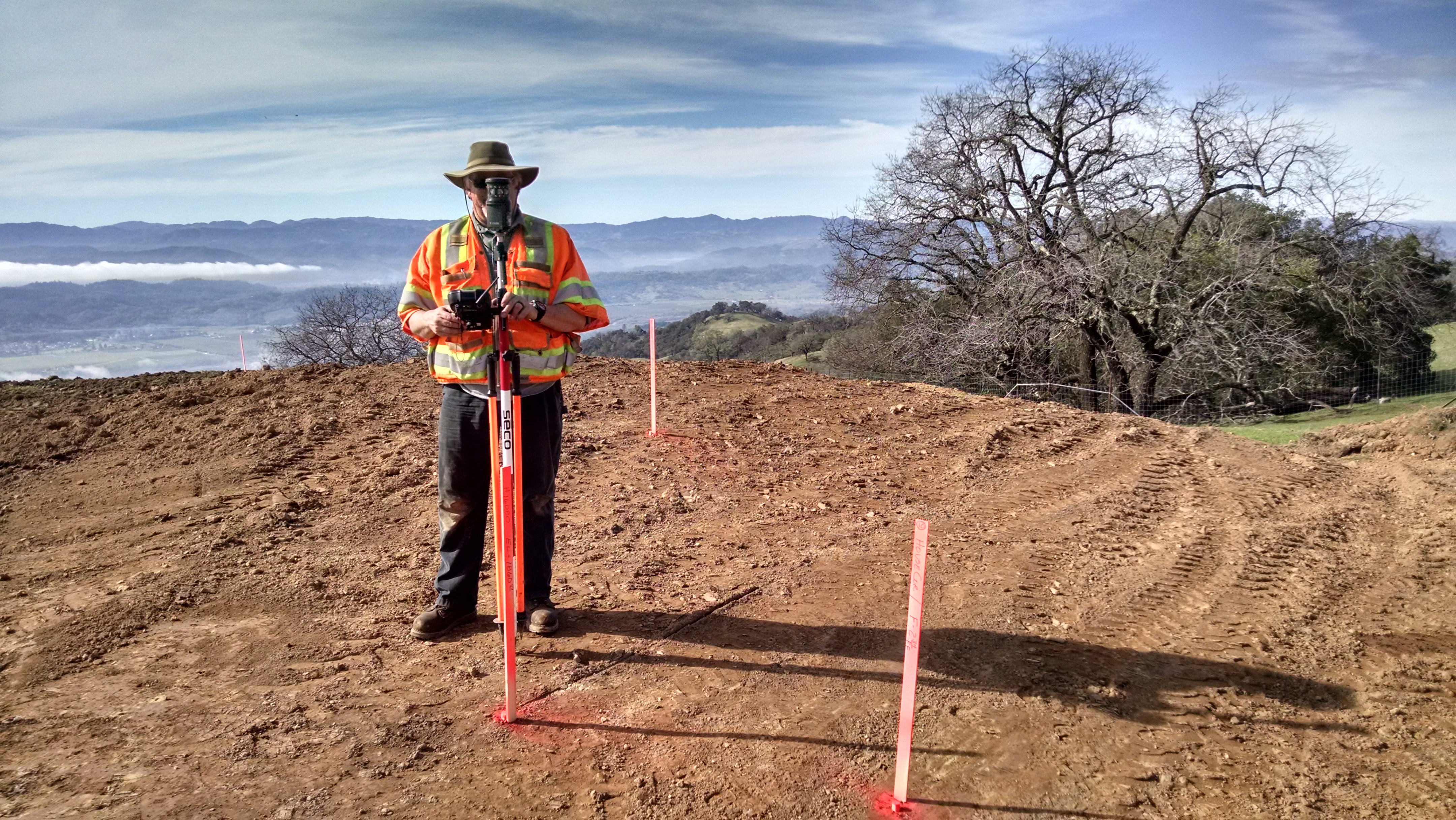
Global Positioning Systems
Global Positioning System (GPS) is a tool to measure distance and elevation between points. It uses a network of satellites in the earth’s orbit that constantly broadcasts information that is then monitored and interpreted by ground-based receivers. When a GPS receiver reports and records a position, it shows the latitude, longitude, and elevation of that point in space, relative to a globally accepted model of the earth. Using GPS helps avoid typical linear and angular surveying errors.
Ray Carlson & Associates is the base station of a Real-Time GPS Network for the North Bay that allows survey-grade GPS with a single rover making work more efficient.
Why use GPS?
Measurement accuracy is paramount when it comes to surveying. Imagine investing in a construction project only to discover it is built partially on your neighbor’s lot. Or selling parcels of land and realizing later that your property boundaries extended farther than you thought or the parcel had more acreage. Ray Carlson & Associates invested in GPS so we could provide our clients with the most accurate surveying measurement. Many surveys, previously considered uneconomical because of terrain or size, are now within economical reach with the use of GPS.
Large parcels of land involving multiple government sections can be surveyed more quickly than conventional ground measurements. Remote boundary corners, unseen for decades, can be located by using the navigational capabilities on board our state-of-the-art GPS equipment.
Why can’t I survey with the GPS on my phone?
Smartphone GPS is usually accurate to within 10 meters or 33 feet, plus or minus, good enough to find a street address but inadequate for finding a survey monument.
Acceptable error for surveys, using GPS, is within a half-inch horizontally and one inch vertically.
Additionally, the raw data from even survey-grade equipment needs to be post-processed, that is, to be run through an error correction regime to further reduce error.
Ray Carlson & Associates uses the latest software and hardware to ensure our surveys are as accurate and precise as the state of the art will achieve.